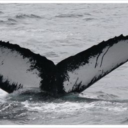
Fluke of Dyad Confirmed in the catalog

Dyad @22140

This whale is known from the collaborative efforts of the Gulf of Maine Humpback Whale Catalog at the Center for Coastal Studies and the North Atlantic Humpback Whale Catalog at Allied Whale, College of the Atlantic. Submissions are matched to these catalogs and contribute to their long-term work, thanks to a partnership with Happywhale. You can view her calf Fuego, her 2018 calf and 2021 calf on Happywhale!

Gulf of Maine · North Atlantic

Public · Not set by this account.

57 Following 28 Followers
17
Sightings
14
Years
2
Crossings
Last 12 months 2 sightings
  1. N 2025-11: 0 sightings
  2. D 2025-12: 0 sightings
  3. J 2026-01: 0 sightings
  4. F 2026-02: 0 sightings
  5. M 2026-03: 0 sightings
  6. A 2026-04: 0 sightings
  7. M 2026-05: 0 sightings
  8. J 2026-06: 0 sightings
  9. J 2026-07: 0 sightings
  10. A 2026-08: 0 sightings
  11. S 2026-09: 2 sightings
  12. O 2026-10: 0 sightings

Activities

12 in Risa
Activity map — real sighting points on an OpenStreetMap basemap © OpenStreetMap contributors
Full House at Sea Sep 13 – 15, 2026 · Gulf of Maine · 2 sightings Deepest dive30 m Longest dive1:21
Activity map — real sighting points on an OpenStreetMap basemap © OpenStreetMap contributors
Gulf of Maine · Oct 2024 Oct 26, 2024 · Gulf of Maine · 1 sighting Deepest dive78 m Longest dive2:30
Activity map — real sighting points on an OpenStreetMap basemap © OpenStreetMap contributors
Gulf of Maine · Jun – Jul 2024 Jun 23 – Jul 4, 2024 · Gulf of Maine · 3 sightings Deepest dive26 m Longest dive1:26
Activity map — real sighting points on an OpenStreetMap basemap © OpenStreetMap contributors
Gulf of Maine · Nov 2023 Nov 6, 2023 · Gulf of Maine · 1 sighting Deepest dive24 m Longest dive1:24
Activity map — real sighting points on an OpenStreetMap basemap © OpenStreetMap contributors
Gulf of Maine · Jun – Jul 2023 Jun 21 – Jul 15, 2023 · Gulf of Maine · 2 sightings Deepest dive64 m Longest dive3:12
Activity map — real sighting points on an OpenStreetMap basemap © OpenStreetMap contributors
Gulf of Maine · Jul – Aug 2022 Jul 27 – Aug 27, 2022 · Gulf of Maine · 2 sightings Deepest dive51 m Longest dive2:20
Activity map — real sighting points on an OpenStreetMap basemap © OpenStreetMap contributors
Gulf of Maine · Aug 2021 Aug 7, 2021 · Gulf of Maine · 1 sighting Deepest dive24 m Longest dive1:23
Activity map — real sighting points on an OpenStreetMap basemap © OpenStreetMap contributors
Gulf of Maine · Aug 2019 Aug 29, 2019 · Gulf of Maine · 1 sighting Deepest dive— Longest dive—
Activity map — real sighting points on an OpenStreetMap basemap © OpenStreetMap contributors
Silver Bank · Feb 2019 Feb 25, 2019 · Silver Bank · 1 sighting Deepest dive— Longest dive—
Activity map — real sighting points on an OpenStreetMap basemap © OpenStreetMap contributors
Gulf of Maine · Sep 2018 Sep 5, 2018 · Gulf of Maine · 1 sighting Deepest dive— Longest dive—
Activity map — real sighting points on an OpenStreetMap basemap © OpenStreetMap contributors
Gulf of Maine · Jul 2016 Jul 12, 2016 · Gulf of Maine · 1 sighting Deepest dive— Longest dive—
Activity map — real sighting points on an OpenStreetMap basemap © OpenStreetMap contributors
Gulf of Maine · May 2013 May 26, 2013 · Gulf of Maine · 1 sighting Deepest dive— Longest dive—

✳ Dive stats modelled, not measured

Sighting records from Happywhale, published as occurrence data via GBIF. Individual records are licensed CC0 1.0, CC BY 4.0 or CC BY-NC 4.0, depending on the contributor.

The photographs and fluke identifications behind every sighting are the work of the contributing observers — the citizen scientists, naturalists and operators who logged them, each named in the underlying GBIF occurrence record. Every activity links out to its source encounters on Happywhale. Basemaps © OpenStreetMap contributors (ODbL).

Happywhale runs on donations: support Happywhale →

Breach is an independent project. It is not affiliated with, nor endorsed by, Happywhale or GBIF.