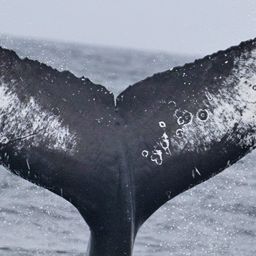
Fluke of Lemur Confirmed in the catalog

Lemur @2512

This whale is known to be male based on photo from Blue Ocean Whale Watch on 10/08/2021.

Monterey Bay · North Pacific

Public · Not set by this account.

72 Following 158 Followers
84
Sightings
17
Years
0
Crossings
Last 12 months 3 sightings
  1. N 2025-11: 0 sightings
  2. D 2025-12: 0 sightings
  3. J 2026-01: 0 sightings
  4. F 2026-02: 0 sightings
  5. M 2026-03: 0 sightings
  6. A 2026-04: 0 sightings
  7. M 2026-05: 0 sightings
  8. J 2026-06: 0 sightings
  9. J 2026-07: 0 sightings
  10. A 2026-08: 1 sighting
  11. S 2026-09: 2 sightings
  12. O 2026-10: 0 sightings

Activities

13 in Risa
Activity map — real sighting points on an OpenStreetMap basemap © OpenStreetMap contributors
Canyon Water, Full Bait Aug 23 – Sep 15, 2026 · Monterey Bay · 3 sightings Deepest dive161 m Longest dive7:46
Activity map — real sighting points on an OpenStreetMap basemap © OpenStreetMap contributors
Monterey Bay · Aug 2025 Aug 25, 2025 · Monterey Bay · 1 sighting Deepest dive72 m Longest dive2:34
Activity map — real sighting points on an OpenStreetMap basemap © OpenStreetMap contributors
Santa Barbara Channel · Mar – Apr 2024 Mar 14 – Apr 6, 2024 · Santa Barbara Channel · 2 sightings Deepest dive87 m Longest dive3:27
Activity map — real sighting points on an OpenStreetMap basemap © OpenStreetMap contributors
Monterey Bay · Sep – Oct 2023 Sep 22 – Oct 4, 2023 · Monterey Bay · 2 sightings Deepest dive186 m Longest dive5:41
Activity map — real sighting points on an OpenStreetMap basemap © OpenStreetMap contributors
Monterey Bay · Jul – Aug 2022 Jul 30 – Aug 1, 2022 · Monterey Bay · 3 sightings Deepest dive55 m Longest dive2:41
Activity map — real sighting points on an OpenStreetMap basemap © OpenStreetMap contributors
Monterey Bay · Jul – Oct 2021 Jul 29 – Oct 9, 2021 · Monterey Bay · 34 sightings Deepest dive274 m Longest dive7:10
Activity map — real sighting points on an OpenStreetMap basemap © OpenStreetMap contributors
Monterey Bay · Jul – Sep 2020 Jul 21 – Sep 2, 2020 · Monterey Bay · 3 sightings Deepest dive110 m Longest dive3:58
Activity map — real sighting points on an OpenStreetMap basemap © OpenStreetMap contributors
North Pacific · Nov 2019 Nov 10, 2019 · North Pacific · 1 sighting Deepest dive77 m Longest dive2:57
Activity map — real sighting points on an OpenStreetMap basemap © OpenStreetMap contributors
Monterey Bay · Jul 2019 Jul 26 – 27, 2019 · Monterey Bay · 2 sightings Deepest dive— Longest dive—
Activity map — real sighting points on an OpenStreetMap basemap © OpenStreetMap contributors
Monterey Bay · Aug – Sep 2018 Aug 17 – Sep 30, 2018 · Monterey Bay · 6 sightings Deepest dive— Longest dive—
Activity map — real sighting points on an OpenStreetMap basemap © OpenStreetMap contributors
Monterey Bay · Aug – Nov 2017 Aug 26 – Nov 15, 2017 · Monterey Bay · 4 sightings Deepest dive— Longest dive—
Activity map — real sighting points on an OpenStreetMap basemap © OpenStreetMap contributors
Santa Barbara Channel · May 2011 May 26, 2011 · Santa Barbara Channel · 1 sighting Deepest dive— Longest dive—
Activity map — real sighting points on an OpenStreetMap basemap © OpenStreetMap contributors
Santa Barbara Channel · Jun 2010 Jun 27, 2010 · Santa Barbara Channel · 1 sighting Deepest dive— Longest dive—

✳ Dive stats modelled, not measured

Sighting records from Happywhale, published as occurrence data via GBIF. Individual records are licensed CC0 1.0, CC BY 4.0 or CC BY-NC 4.0, depending on the contributor.

The photographs and fluke identifications behind every sighting are the work of the contributing observers — the citizen scientists, naturalists and operators who logged them, each named in the underlying GBIF occurrence record. Every activity links out to its source encounters on Happywhale. Basemaps © OpenStreetMap contributors (ODbL).

Happywhale runs on donations: support Happywhale →

Breach is an independent project. It is not affiliated with, nor endorsed by, Happywhale or GBIF.