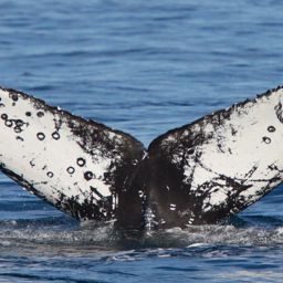
Fluke of Check Confirmed in the catalog

Check @2

Check is named for the apparent check mark on the right fluke, likely the result of a killer whale interaction. Check suffered an extended entanglement between at least October 2024 and April 2025, cut free by an entanglement response team in Monterey Bay, California. For Happywhale, Check goes right back to the beginning of this system, the 2nd whale entered into the now-global database. This whale is known from research conducted by Cascadia Research Collective and collaborators, and is known in Mexico to ECOBAC from the photo-identification catalog of humpback whale of Banderas Bay, Mexico (FIBB catalog). Known as male from a biopsy sample collected by Proyecto Megaptera El Salvador and PRIMMA 01/20/2024 and analyzed at Dr. Omar Chassin’s lab (UMSNH).

Monterey Bay · North Pacific

Public · Not set by this account.

61 Following 111 Followers
96
Sightings
15
Years
0
Crossings
Last 12 months 1 sighting
  1. N 2025-11: 0 sightings
  2. D 2025-12: 0 sightings
  3. J 2026-01: 1 sighting
  4. F 2026-02: 0 sightings
  5. M 2026-03: 0 sightings
  6. A 2026-04: 0 sightings
  7. M 2026-05: 0 sightings
  8. J 2026-06: 0 sightings
  9. J 2026-07: 0 sightings
  10. A 2026-08: 0 sightings
  11. S 2026-09: 0 sightings
  12. O 2026-10: 0 sightings

Activities

17 in Risa
Activity map — real sighting points on an OpenStreetMap basemap © OpenStreetMap contributors
Monterey Bay Return Apr 9 – Jul 11, 2025 · Monterey Bay · 3 sightings Deepest dive52 m Longest dive1:53
Activity map — real sighting points on an OpenStreetMap basemap © OpenStreetMap contributors
Monterey Bay · Oct 2024 Oct 13, 2024 · Monterey Bay · 1 sighting Deepest dive76 m Longest dive3:08
Activity map — real sighting points on an OpenStreetMap basemap © OpenStreetMap contributors
Monterey Bay · Sep 2023 Sep 6, 2023 · Monterey Bay · 1 sighting Deepest dive153 m Longest dive4:31
Activity map — real sighting points on an OpenStreetMap basemap © OpenStreetMap contributors
North Pacific · Mar 2023 Mar 15, 2023 · North Pacific · 1 sighting Deepest dive17 m Longest dive0:58
Activity map — real sighting points on an OpenStreetMap basemap © OpenStreetMap contributors
North Pacific · Oct 2022 Oct 30, 2022 · North Pacific · 1 sighting Deepest dive43 m Longest dive1:38
Activity map — real sighting points on an OpenStreetMap basemap © OpenStreetMap contributors
Monterey Bay · Apr 2022 Apr 12, 2022 · Monterey Bay · 1 sighting Deepest dive87 m Longest dive2:52
Activity map — real sighting points on an OpenStreetMap basemap © OpenStreetMap contributors
Monterey Bay · Apr – May 2021 Apr 24 – May 17, 2021 · Monterey Bay · 5 sightings Deepest dive58 m Longest dive2:22
Activity map — real sighting points on an OpenStreetMap basemap © OpenStreetMap contributors
Monterey Bay · Sep 2020 Sep 27, 2020 · Monterey Bay · 1 sighting Deepest dive75 m Longest dive2:21
Activity map — real sighting points on an OpenStreetMap basemap © OpenStreetMap contributors
Monterey Bay · Mar – May 2020 Mar 28 – May 1, 2020 · Monterey Bay · 5 sightings Deepest dive188 m Longest dive9:26
Activity map — real sighting points on an OpenStreetMap basemap © OpenStreetMap contributors
Monterey Bay · Oct – Nov 2019 Oct 4 – Nov 1, 2019 · Monterey Bay · 7 sightings Deepest dive175 m Longest dive5:39
Activity map — real sighting points on an OpenStreetMap basemap © OpenStreetMap contributors
Monterey Bay · Apr 2019 Apr 13, 2019 · Monterey Bay · 2 sightings Deepest dive— Longest dive—
Activity map — real sighting points on an OpenStreetMap basemap © OpenStreetMap contributors
Monterey Bay · Apr – Aug 2018 Apr 4 – Aug 24, 2018 · Monterey Bay · 12 sightings Deepest dive— Longest dive—
Activity map — real sighting points on an OpenStreetMap basemap © OpenStreetMap contributors
Monterey Bay · Mar – Oct 2017 Mar 19 – Oct 5, 2017 · Monterey Bay · 8 sightings Deepest dive— Longest dive—
Activity map — real sighting points on an OpenStreetMap basemap © OpenStreetMap contributors
Monterey Bay · Mar 2015 Mar 27, 2015 · Monterey Bay · 1 sighting Deepest dive— Longest dive—
Activity map — real sighting points on an OpenStreetMap basemap © OpenStreetMap contributors
Monterey Bay · Oct 2014 Oct 9 – 27, 2014 · Monterey Bay · 2 sightings Deepest dive— Longest dive—
Activity map — real sighting points on an OpenStreetMap basemap © OpenStreetMap contributors
Monterey Bay · May 2014 May 1 – 22, 2014 · Monterey Bay · 2 sightings Deepest dive— Longest dive—
Activity map — real sighting points on an OpenStreetMap basemap © OpenStreetMap contributors
Monterey Bay · Apr – May 2012 Apr 24 – May 26, 2012 · Monterey Bay · 2 sightings Deepest dive— Longest dive—

✳ Dive stats modelled, not measured

Sighting records from Happywhale, published as occurrence data via GBIF. Individual records are licensed CC0 1.0, CC BY 4.0 or CC BY-NC 4.0, depending on the contributor.

The photographs and fluke identifications behind every sighting are the work of the contributing observers — the citizen scientists, naturalists and operators who logged them, each named in the underlying GBIF occurrence record. Every activity links out to its source encounters on Happywhale. Basemaps © OpenStreetMap contributors (ODbL).

Happywhale runs on donations: support Happywhale →

Breach is an independent project. It is not affiliated with, nor endorsed by, Happywhale or GBIF.