Activity map — real sighting points on an OpenStreetMap basemap © OpenStreetMap contributors
Monterey Bay

Foster Mom – Residency

23rd sighting in Monterey Bay
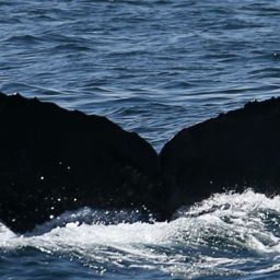
Fluke of Foster Mom
Foster Mom Confirmed in the catalog @3125
Apr 18 – Sep 12, 2015 · Monterey Bay

Monterey Bay · Apr – Sep 2015

—
Deepest dive
—
Longest dive
—
Dives
Sightings
21
Days between first and last sighting
147

Dive stats modelled within real depth limits — not measured

Get actual dive data with Risa Deep →
SightingSeafloorSea tempDeepest dive (modelled)
Apr 18, 2015254 m12.4°C—
Apr 21, 2015254 m12.0°C—
May 1, 2015254 m13.0°C—
May 3, 2015254 m12.7°C—
May 8, 201573 m12.2°C—
May 15, 2015567 m12.0°C—
May 16, 2015254 m12.3°C—
May 17, 2015254 m12.0°C—
May 28, 201571 m12.8°C—
May 29, 2015178 m12.7°C—
Jun 7, 2015143 m13.1°C—
Jun 8, 201551 m13.9°C—
Jun 10, 201573 m14.1°C—
Jun 11, 201574 m14.4°C—
Jun 13, 2015123 m14.7°C—
Jun 15, 2015163 m14.7°C—
Jun 20, 2015142 m13.8°C—
Jun 21, 201579 m14.0°C—

Seafloor and sea temperature measured · ✳ dives modelled ·

Activity map — real sighting points on an OpenStreetMap basemap © OpenStreetMap contributors

Deepest dive against the seafloor, per sighting

Seafloor · measured Deepest dive · modelled
Apr 18, 2015 — seafloor 254 m (measured), deepest dive — (modelled)Apr 18Apr 21, 2015 — seafloor 254 m (measured), deepest dive — (modelled)May 1, 2015 — seafloor 254 m (measured), deepest dive — (modelled)May 3, 2015 — seafloor 254 m (measured), deepest dive — (modelled)May 8, 2015 — seafloor 73 m (measured), deepest dive — (modelled)May 8May 15, 2015 — seafloor 567 m (measured), deepest dive — (modelled)May 16, 2015 — seafloor 254 m (measured), deepest dive — (modelled)May 17, 2015 — seafloor 254 m (measured), deepest dive — (modelled)May 28, 2015 — seafloor 71 m (measured), deepest dive — (modelled)May 28May 29, 2015 — seafloor 178 m (measured), deepest dive — (modelled)Jun 7, 2015 — seafloor 143 m (measured), deepest dive — (modelled)Jun 8, 2015 — seafloor 51 m (measured), deepest dive — (modelled)Jun 10, 2015 — seafloor 73 m (measured), deepest dive — (modelled)Jun 10Jun 11, 2015 — seafloor 74 m (measured), deepest dive — (modelled)Jun 13, 2015 — seafloor 123 m (measured), deepest dive — (modelled)Jun 15, 2015 — seafloor 163 m (measured), deepest dive — (modelled)Jun 20, 2015 — seafloor 142 m (measured), deepest dive — (modelled)Jun 20Jun 21, 2015 — seafloor 79 m (measured), deepest dive — (modelled)Jun 23, 2015 — seafloor 126 m (measured), deepest dive — (modelled)Sep 11, 2015 — seafloor 585 m (measured), deepest dive — (modelled)Sep 12, 2015 — seafloor 144 m (measured), deepest dive — (modelled)Sep 12

Depth runs down from the surface. The modelled dive never passes the measured seafloor at that sighting.

Dives

—
Deepest dive
—
Longest dive
—
Dives
—
Avg dive depth
21
Sightings
147
Days first → last

Dive metrics are modelled within real depth limits — not measured

Get actual dive data with Risa Deep →

Dive profile

modelled
02550startdive sequence (illustrative)

Modelled from the published dive-behaviour distribution. Not measured.

Deep Effort Score

Deep

Depth, duration and recovery resolved into a single number for this session.

Unlock with Risa Deep

Place

Where this happened · Sep 12, 2015

measured
Seafloor depth
144 m
Sea-surface temperature
17.0°C
Distance from shore
2.0 km

Across the residency · 21 sightings

measured
Seafloor depth
51 m – 585 m
Sea-surface temperature
12.0°C – 18.1°C
Distance from shore
2.0 km – 19.0 km

Sources: GEBCO seafloor grid · NASA JPL MUR sea temperature · PacIOOS coastline distance

Activity map — real sighting points on an OpenStreetMap basemap © OpenStreetMap contributors

Source records

This activity is assembled from 21 catalogued encounters on Happywhale.

Sighting records from Happywhale, published as occurrence data via GBIF. Individual records are licensed CC0 1.0, CC BY 4.0 or CC BY-NC 4.0, depending on the contributor.

The photographs and fluke identifications behind every sighting are the work of the contributing observers — the citizen scientists, naturalists and operators who logged them, each named in the underlying GBIF occurrence record. Every activity links out to its source encounters on Happywhale. Basemaps © OpenStreetMap contributors (ODbL).

Happywhale runs on donations: support Happywhale →

Breach is an independent project. It is not affiliated with, nor endorsed by, Happywhale or GBIF.