CRC-17986 – Residency
5th sighting in Salish Sea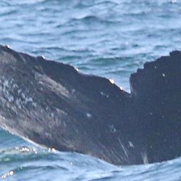
CRC-17986 @43460
Sep 5 – Oct 11, 2026 · Salish Sea
Herring Corner, Cold Water
Found the tide's pushing the herring into my favorite corner again—wait, can't say that. Found the herring exactly where this cold water always hides them.
83 m
Deepest dive
3:17
Longest dive
34
Dives
- Sightings
- 3
- Days between first and last sighting
- 36
- Deepest dive on record
- 83 m · this residency
Dive stats modelled within real depth limits — not measured
Get actual dive data with Risa Deep →| Sighting | Seafloor | Sea temp | Deepest dive (modelled) |
|---|---|---|---|
| Sep 5, 2026 | 109 m | — | 24 m |
| Sep 7, 2026 | 125 m | — | 83 m |
| Oct 11, 2026 | 158 m | — | 56 m |
Seafloor and sea temperature measured · ✳ dives modelled

Deepest dive against the seafloor, per sighting
Seafloor · measured Deepest dive · modelledDepth runs down from the surface. The modelled dive never passes the measured seafloor at that sighting.
Dives
83 m
Deepest dive
3:17
Longest dive
34
Dives
23 m
Avg dive depth
3
Sightings
36
Days first → last
Dive metrics are modelled within real depth limits — not measured
Get actual dive data with Risa Deep →Dive profile
modelledDepth shaped by the seafloor limit here (125 m) and the published dive-behaviour distribution. Modelled, not measured.
Deep Effort Score
DeepPlace
Where this happened · Sep 7, 2026
measured- Seafloor depth
- 125 m
- Sea-surface temperature
- —
- Distance from shore
- 4.0 km
Across the residency · 3 sightings
measured- Seafloor depth
- 109 m – 158 m
- Sea-surface temperature
- —
- Distance from shore
- 4.0 km – 7.0 km
Sources: GEBCO seafloor grid · PacIOOS coastline distance
Source records
This activity is assembled from 3 catalogued encounters on Happywhale.