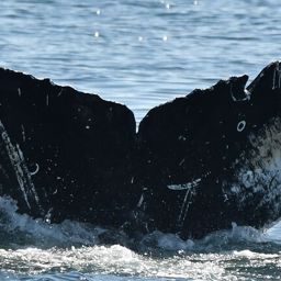
Fluke of SuperNova Confirmed in the catalog

SuperNova @7158

SuperNova is known as a female from research by NOAA Southwest Fisheries Science Center (SWFSC) and observation with a calf. Mother of CRC-17885 (2019), and 2024 calf known from observation of mother and calf pair on Oct 5th, 2024 in British Columbia according to Selena Rhodes Scofield and 2026 calf from observation of mother and calf pair on Mar 19th, 2026 in Mexico according to Whale Watch Cabo.

Salish Sea · North Pacific

Public · Not set by this account.

68 Following 33 Followers
24
Sightings
20
Years
9
Crossings
Last 12 months 1 sighting
  1. N 2025-11: 0 sightings
  2. D 2025-12: 0 sightings
  3. J 2026-01: 0 sightings
  4. F 2026-02: 0 sightings
  5. M 2026-03: 1 sighting
  6. A 2026-04: 0 sightings
  7. M 2026-05: 0 sightings
  8. J 2026-06: 0 sightings
  9. J 2026-07: 0 sightings
  10. A 2026-08: 0 sightings
  11. S 2026-09: 0 sightings
  12. O 2026-10: 0 sightings

Activities

14 in Risa
Activity map — real sighting points on an OpenStreetMap basemap © OpenStreetMap contributors
Gulf of California · Mar 2026 Mar 19, 2026 · Gulf of California · 1 sighting Deepest dive15 m Longest dive0:58
Activity map — real sighting points on an OpenStreetMap basemap © OpenStreetMap contributors
Salish Sea · Oct 2024 Oct 5, 2024 · Salish Sea · 1 sighting Deepest dive44 m Longest dive1:41
Activity map — real sighting points on an OpenStreetMap basemap © OpenStreetMap contributors
Banderas Bay · Dec 2021 – Jan 2022 Dec 17, 2021 – Jan 10, 2022 · Banderas Bay · 3 sightings Deepest dive77 m Longest dive3:00
Activity map — real sighting points on an OpenStreetMap basemap © OpenStreetMap contributors
Banderas Bay · Mar 2021 Mar 11, 2021 · Banderas Bay · 1 sighting Deepest dive20 m Longest dive1:05
Activity map — real sighting points on an OpenStreetMap basemap © OpenStreetMap contributors
Salish Sea · Aug 2020 Aug 23, 2020 · Salish Sea · 1 sighting Deepest dive140 m Longest dive5:29
Activity map — real sighting points on an OpenStreetMap basemap © OpenStreetMap contributors
Gulf of California · Feb 2020 Feb 12, 2020 · Gulf of California · 1 sighting Deepest dive102 m Longest dive3:10
Activity map — real sighting points on an OpenStreetMap basemap © OpenStreetMap contributors
Salish Sea · Aug – Sep 2019 Aug 11 – Sep 4, 2019 · Salish Sea · 4 sightings Deepest dive107 m Longest dive4:25
Activity map — real sighting points on an OpenStreetMap basemap © OpenStreetMap contributors
Gulf of California · Jan 2019 Jan 7, 2019 · Gulf of California · 1 sighting Deepest dive17 m Longest dive1:10
Activity map — real sighting points on an OpenStreetMap basemap © OpenStreetMap contributors
Salish Sea · Sep 2018 Sep 14, 2018 · Salish Sea · 1 sighting Deepest dive75 m Longest dive3:35
Activity map — real sighting points on an OpenStreetMap basemap © OpenStreetMap contributors
Banderas Bay · Mar 2018 Mar 13 – 28, 2018 · Banderas Bay · 3 sightings Deepest dive57 m Longest dive2:12
Activity map — real sighting points on an OpenStreetMap basemap © OpenStreetMap contributors
Salish Sea · Oct 2017 Oct 8, 2017 · Salish Sea · 1 sighting Deepest dive119 m Longest dive3:07
Activity map — real sighting points on an OpenStreetMap basemap © OpenStreetMap contributors
North Pacific · Jan 2017 Jan 20, 2017 · North Pacific · 1 sighting Deepest dive56 m Longest dive2:04
Activity map — real sighting points on an OpenStreetMap basemap © OpenStreetMap contributors
North Pacific · Mar 2013 Mar 13, 2013 · North Pacific · 1 sighting Deepest dive229 m Longest dive7:38
Activity map — real sighting points on an OpenStreetMap basemap © OpenStreetMap contributors
Salish Sea · Aug 2007 Aug 13, 2007 · Salish Sea · 1 sighting Deepest dive44 m Longest dive1:50

✳ Dive stats modelled, not measured

Sighting records from Happywhale, published as occurrence data via GBIF. Individual records are licensed CC0 1.0, CC BY 4.0 or CC BY-NC 4.0, depending on the contributor.

The photographs and fluke identifications behind every sighting are the work of the contributing observers — the citizen scientists, naturalists and operators who logged them, each named in the underlying GBIF occurrence record. Every activity links out to its source encounters on Happywhale. Basemaps © OpenStreetMap contributors (ODbL).

Happywhale runs on donations: support Happywhale →

Breach is an independent project. It is not affiliated with, nor endorsed by, Happywhale or GBIF.