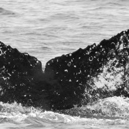
Fluke of Fingers Confirmed in the catalog

Fingers @7529

"Fingers" aka CRC-12223 was first seen to the best of our knowledge in the breeding season of 2006 in Vallarta, Mexico. Since then Fingers has been regularly seen in Monterey Bay and off the Farallones Islands as recently as this August. Fingers lost half of his or her left fluke at some point between 2014 and 2017, and suffered a major propeller wound to the left flank. Fortunately, the wound to the flank did not penetrate muscle. A major study in the Gulf of Maine (Hill et al., 2017) showed that for wounds that resightings were very rare for whales with deeper wounds, strongly implying that once a ship strike wound cuts into muscle, the whale is extremely likely to die. How can we keep our whales safe? As the British Columbia based Marine Education and Research Society says, "See a blow, go slow!" Travel slowly and be alert when in waters with whales. Bulk shipping represents a large threat to whales, The biggest threat to whales But the real issue comes from large vessels; thanks to efforts of California marine conservation organizations, there is growing momentum to instigate speed limits through the whale rich waters at the mouth of San Francisco Bay. What we know of Fingers is thanks to collaborative research conducted by Cascadia Research Collective, and in Mexico, ECOBAC from the photo-identification catalog of humpback whale of Banderas Bay, Mexico (FIBB catalog).

Monterey Bay · North Pacific

Public · Not set by this account.

86 Following 61 Followers
29
Sightings
21
Years
0
Crossings
Last 12 months 2 sightings
  1. N 2025-11: 0 sightings
  2. D 2025-12: 0 sightings
  3. J 2026-01: 0 sightings
  4. F 2026-02: 0 sightings
  5. M 2026-03: 0 sightings
  6. A 2026-04: 0 sightings
  7. M 2026-05: 0 sightings
  8. J 2026-06: 1 sighting
  9. J 2026-07: 1 sighting
  10. A 2026-08: 0 sightings
  11. S 2026-09: 0 sightings
  12. O 2026-10: 0 sightings

Activities

13 in Risa
Activity map — real sighting points on an OpenStreetMap basemap © OpenStreetMap contributors
Home Water, Early Summer Jun 19 – Jul 11, 2026 · Monterey Bay · 2 sightings Deepest dive74 m Longest dive2:40
Activity map — real sighting points on an OpenStreetMap basemap © OpenStreetMap contributors
Monterey Bay · Jun – Jul 2025 Jun 29 – Jul 3, 2025 · Monterey Bay · 3 sightings Deepest dive139 m Longest dive5:30
Activity map — real sighting points on an OpenStreetMap basemap © OpenStreetMap contributors
Gulf of California · Jan 2025 Jan 21, 2025 · Gulf of California · 1 sighting Deepest dive74 m Longest dive2:59
Activity map — real sighting points on an OpenStreetMap basemap © OpenStreetMap contributors
Monterey Bay · Jul – Aug 2024 Jul 29 – Aug 9, 2024 · Monterey Bay · 2 sightings Deepest dive169 m Longest dive5:50
Activity map — real sighting points on an OpenStreetMap basemap © OpenStreetMap contributors
Gulf of California · Feb 2024 Feb 14, 2024 · Gulf of California · 1 sighting Deepest dive19 m Longest dive1:18
Activity map — real sighting points on an OpenStreetMap basemap © OpenStreetMap contributors
Gulf of California · Jan 2023 Jan 23, 2023 · Gulf of California · 1 sighting Deepest dive62 m Longest dive2:46
Activity map — real sighting points on an OpenStreetMap basemap © OpenStreetMap contributors
Monterey Bay · Jul 2022 Jul 3, 2022 · Monterey Bay · 1 sighting Deepest dive53 m Longest dive1:59
Activity map — real sighting points on an OpenStreetMap basemap © OpenStreetMap contributors
Gulf of California · Feb 2022 Feb 18, 2022 · Gulf of California · 1 sighting Deepest dive133 m Longest dive6:19
Activity map — real sighting points on an OpenStreetMap basemap © OpenStreetMap contributors
Gulf of the Farallones · Oct 2021 Oct 17, 2021 · Gulf of the Farallones · 1 sighting Deepest dive35 m Longest dive1:49
Activity map — real sighting points on an OpenStreetMap basemap © OpenStreetMap contributors
Gulf of the Farallones · Aug 2018 Aug 19 – 25, 2018 · Gulf of the Farallones · 2 sightings Deepest dive93 m Longest dive3:13
Activity map — real sighting points on an OpenStreetMap basemap © OpenStreetMap contributors
Monterey Bay · Jun – Aug 2017 Jun 26 – Aug 4, 2017 · Monterey Bay · 4 sightings Deepest dive63 m Longest dive2:31
Activity map — real sighting points on an OpenStreetMap basemap © OpenStreetMap contributors
North Pacific · Feb 2014 Feb 26, 2014 · North Pacific · 1 sighting Deepest dive67 m Longest dive2:09
Activity map — real sighting points on an OpenStreetMap basemap © OpenStreetMap contributors
Banderas Bay · Jan 2006 Jan 12, 2006 · Banderas Bay · 1 sighting Deepest dive45 m Longest dive1:48

✳ Dive stats modelled, not measured

Sighting records from Happywhale, published as occurrence data via GBIF. Individual records are licensed CC0 1.0, CC BY 4.0 or CC BY-NC 4.0, depending on the contributor.

The photographs and fluke identifications behind every sighting are the work of the contributing observers — the citizen scientists, naturalists and operators who logged them, each named in the underlying GBIF occurrence record. Every activity links out to its source encounters on Happywhale. Basemaps © OpenStreetMap contributors (ODbL).

Happywhale runs on donations: support Happywhale →

Breach is an independent project. It is not affiliated with, nor endorsed by, Happywhale or GBIF.