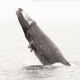
Fluke of Lefty Confirmed in the catalog

Lefty @934

"Lefty" the Humpback Whale is a male who is missing his left pectoral flipper - likely from an entanglement many years ago. Our friends at Cascadia Research Collective have identified him as CRC-12254, biopsy determined his gender. His first sighting known to us is by our dear friend and sorely missed Richard Ternullo on 20 June 2008. In May 2012, Lefty was part of an extended Humpback Whale - Bigg's (Transient) Killer Whale - Gray Whale encounter also in these videos - (1), (video 2), (video 3) and part of a paper by Pitman et al. And see the excellent Hakai Magazine article about this and other inter-species whale encounters Formerly also CRC-15424, HW-MN0500878, HW-MN0500824

Monterey Bay · North Pacific

Public · Not set by this account.

76 Following 768 Followers
228
Sightings
19
Years
0
Crossings
Last 12 months 13 sightings
  1. N 2025-11: 0 sightings
  2. D 2025-12: 0 sightings
  3. J 2026-01: 0 sightings
  4. F 2026-02: 0 sightings
  5. M 2026-03: 1 sighting
  6. A 2026-04: 0 sightings
  7. M 2026-05: 1 sighting
  8. J 2026-06: 0 sightings
  9. J 2026-07: 1 sighting
  10. A 2026-08: 4 sightings
  11. S 2026-09: 1 sighting
  12. O 2026-10: 5 sightings

Activities

18 in Risa
Activity map — real sighting points on an OpenStreetMap basemap © OpenStreetMap contributors
Summer in the Bay May 29 – Oct 27, 2025 · Monterey Bay · 14 sightings Deepest dive129 m Longest dive5:04
Activity map — real sighting points on an OpenStreetMap basemap © OpenStreetMap contributors
Oaxaca Coast · Feb 2025 Feb 2, 2025 · Oaxaca Coast · 1 sighting Deepest dive79 m Longest dive2:58
Activity map — real sighting points on an OpenStreetMap basemap © OpenStreetMap contributors
Monterey Summer Jul 16 – Oct 21, 2023 · Monterey Bay · 21 sightings Deepest dive186 m Longest dive5:23
Activity map — real sighting points on an OpenStreetMap basemap © OpenStreetMap contributors
Monterey Mornings Aug 7 – Nov 5, 2022 · Monterey Bay · 25 sightings Deepest dive126 m Longest dive5:35
Activity map — real sighting points on an OpenStreetMap basemap © OpenStreetMap contributors
North Pacific · Apr 2022 Apr 12, 2022 · North Pacific · 1 sighting Deepest dive93 m Longest dive3:35
Activity map — real sighting points on an OpenStreetMap basemap © OpenStreetMap contributors
Monterey Bay Summer May 15 – Nov 24, 2021 · Monterey Bay · 30 sightings Deepest dive193 m Longest dive8:21
Activity map — real sighting points on an OpenStreetMap basemap © OpenStreetMap contributors
Monterey Bay · Sep – Nov 2020 Sep 23 – Nov 10, 2020 · Monterey Bay · 13 sightings Deepest dive137 m Longest dive4:15
Activity map — real sighting points on an OpenStreetMap basemap © OpenStreetMap contributors
Monterey Bay · Oct 2019 Oct 2 – 31, 2019 · Monterey Bay · 6 sightings Deepest dive111 m Longest dive4:21
Activity map — real sighting points on an OpenStreetMap basemap © OpenStreetMap contributors
Monterey Bay · Apr – May 2019 Apr 17 – May 4, 2019 · Monterey Bay · 11 sightings Deepest dive225 m Longest dive11:15
Activity map — real sighting points on an OpenStreetMap basemap © OpenStreetMap contributors
Monterey Bay · May – Nov 2018 May 18 – Nov 2, 2018 · Monterey Bay · 25 sightings Deepest dive153 m Longest dive6:37
Activity map — real sighting points on an OpenStreetMap basemap © OpenStreetMap contributors
North Pacific · Jul – Aug 2017 Jul 10 – Aug 31, 2017 · North Pacific · 3 sightings Deepest dive28 m Longest dive1:29
Activity map — real sighting points on an OpenStreetMap basemap © OpenStreetMap contributors
Monterey Bay · May – Jun 2015 May 24 – Jun 23, 2015 · Monterey Bay · 4 sightings Deepest dive97 m Longest dive3:18
Activity map — real sighting points on an OpenStreetMap basemap © OpenStreetMap contributors
Monterey Bay · Sep 2014 Sep 5, 2014 · Monterey Bay · 1 sighting Deepest dive49 m Longest dive2:33
Activity map — real sighting points on an OpenStreetMap basemap © OpenStreetMap contributors
Monterey Bay · Sep 2012 Sep 1, 2012 · Monterey Bay · 1 sighting Deepest dive41 m Longest dive2:19
Activity map — real sighting points on an OpenStreetMap basemap © OpenStreetMap contributors
Monterey Bay · May 2012 May 10 – 13, 2012 · Monterey Bay · 2 sightings Deepest dive54 m Longest dive2:05
Activity map — real sighting points on an OpenStreetMap basemap © OpenStreetMap contributors
North Pacific · Feb 2012 Feb 3, 2012 · North Pacific · 1 sighting Deepest dive38 m Longest dive1:35
Activity map — real sighting points on an OpenStreetMap basemap © OpenStreetMap contributors
Monterey Bay · Apr 2009 Apr 5 – 10, 2009 · Monterey Bay · 2 sightings Deepest dive261 m Longest dive10:02
Activity map — real sighting points on an OpenStreetMap basemap © OpenStreetMap contributors
Monterey Bay · Jun 2008 Jun 20, 2008 · Monterey Bay · 1 sighting Deepest dive168 m Longest dive6:56

✳ Dive stats modelled, not measured

Sighting records from Happywhale, published as occurrence data via GBIF. Individual records are licensed CC0 1.0, CC BY 4.0 or CC BY-NC 4.0, depending on the contributor.

The photographs and fluke identifications behind every sighting are the work of the contributing observers — the citizen scientists, naturalists and operators who logged them, each named in the underlying GBIF occurrence record. Every activity links out to its source encounters on Happywhale. Basemaps © OpenStreetMap contributors (ODbL).

Happywhale runs on donations: support Happywhale →

Breach is an independent project. It is not affiliated with, nor endorsed by, Happywhale or GBIF.